
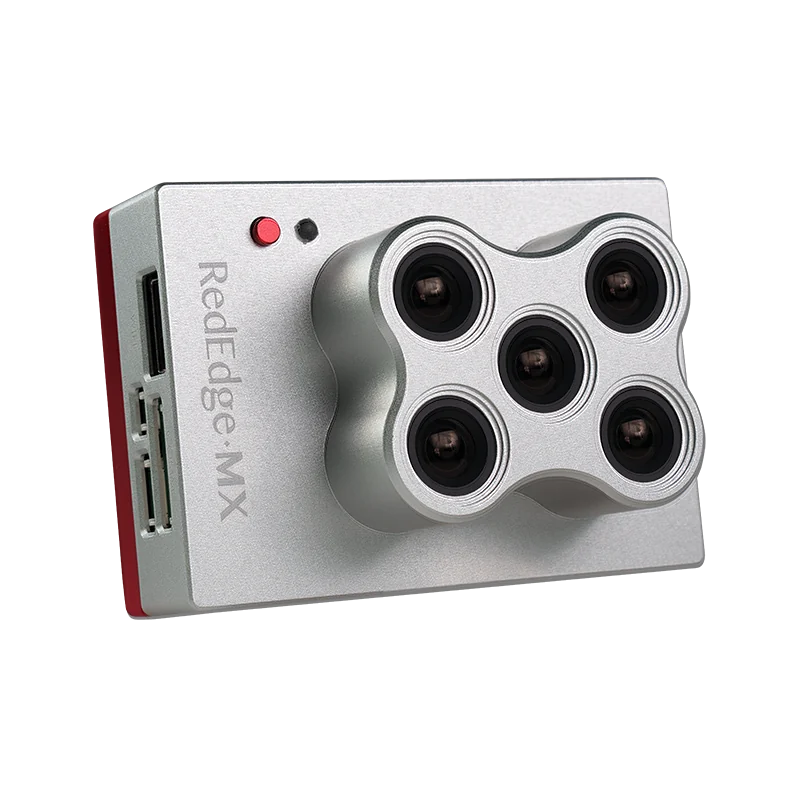
MicaSense RedEdge-MX — Professional Multispectral Drone Camera

Proven Multispectral Technology for Vegetation Mapping

A focused five-band sensor for established vegetation-index, agricultural research and environmental monitoring workflows.

RedEdge-MX records blue, green, red, red-edge and near-infrared imagery for reflectance maps, multispectral orthomosaics and vegetation indices. EagleNXT reintroduced the updated sensor in July 2026 with a new metallic enclosure; it is presented here as a current manufacturer product, not a discontinued legacy camera.

Technical content updated 17 November 2026 · checked against official manufacturer sources
Current MicaSense RedEdge-MX five-band multispectral drone camera with metallic enclosure
Current RedEdge-MX hardware. Official manufacturer reference image.
05multispectral bands
GLOBALshutter imaging
≈8 CMper pixel at 120 m AGL
DLS 2incident-light workflow

RedEdge-MX specifications and workflow context

Manufacturer specifications are shown with their acquisition or processing conditions. Confirm the current configuration and intended outputs before procurement.

01
Multispectral imaging

5 bands

Blue, green, red, red edge and near-infrared
02
Shutter

Global shutter

Multispectral imaging
03
Published GSD

Approximately 8 cm/pixel at 120 m AGL

Manufacturer-published value; actual project GSD depends on acquisition geometry
04
Radiometric workflow

DLS 2 + calibrated reflectance panel

Follow the applicable capture and processing procedure
05
Current product context

Updated model reintroduced July 2026

Manufacturer announcement; local supply is confirmed by quotation

Specify the output before the payload.

A focused entry into calibrated five-band vegetation workflows without panchromatic or thermal imaging.

Agricultural consultants, universities, environmental teams, plantation managers, conservation organisations and drone service providers building an established five-band workflow.

Review the intended configuration

Five wavelength ranges for vegetation analysis.

Current manufacturer centre wavelengths and bandwidths for the updated RedEdge-MX.

RedEdge-MX spectral bands

BandCentreBandwidth
Blue475 nm20 nm
Green560 nm20 nm
Red668 nm10 nm
Red edge717 nm10 nm
Near-infrared840 nm40 nm

What changes in the field and in processing.

The practical reasons to choose RedEdge-MX, with the integration and interpretation boundaries kept visible.

01

01 / WHY FIVE BANDS

Build a repeatable vegetation baseline without adding thermal complexity.

RedEdge-MX is suited to projects that need the established red, red-edge and near-infrared measurements behind indices such as NDVI and NDRE. Its role is to measure spectral response consistently—not to diagnose why a plant or habitat is changing.

Technical boundary: An index map is an analytical layer. Species, canopy structure, illumination, soil background and management conditions all affect interpretation.

  • Compare vegetation patterns across fields, plots or managed landscapes
  • Generate calibrated reflectance products with compatible software
  • Repeat acquisition using a consistent calibration and flight method
02

02 / CURRENT HARDWARE

A 2026 update to an established multispectral workflow.

EagleNXT announced the updated RedEdge-MX in July 2026 and later announced shipping from its Allen, Texas facility. Those manufacturer statements do not establish Easepect stock or a delivery date. Configuration, integration and current commercial terms should be confirmed in a quotation.

  • New metallic enclosure on the updated sensor
  • DLS 2 incident-light sensor and reflectance-panel workflow
  • Compatible drone mounting and triggering remain configuration-specific
03

03 / FIELD TO MAP

Control radiometry before comparing dates.

Capture the calibrated reflectance panel according to the manufacturer procedure, use DLS 2 correctly and document illumination and flight conditions. Processing then aligns the imagery and derives reflectance and index products. Ground observations remain necessary when the objective is to explain an anomaly.

  • Define target vegetation and monitoring interval
  • Check panel captures, DLS 2 data and image quality
  • Validate spatial patterns with field evidence before action

Where this sensor can contribute.

Representative application contexts, not claimed Easepect customer outcomes. Suitability depends on the target, acquisition design, processing method and validation.

01

Crop and plantation monitoring

Map relative vegetation variation and identify areas for agronomic review or targeted scouting.

Discuss this application
02

Agricultural research

Compare plots and treatments while retaining field measurements and experimental controls.

Discuss this application
03

Wetlands and restoration

Document vegetation distribution and change with appropriately planned repeat surveys.

Discuss this application
04

Land-cover monitoring

Build georeferenced spectral layers for GIS analysis and validated classification work.

Discuss this application

Who should consider RedEdge-MX?

Agricultural consultants, universities, environmental teams, plantation managers, conservation organisations and drone service providers building an established five-band workflow.

RedEdge-MX does not include the integrated thermal capability of Altum-PT models or the panchromatic imaging of RedEdge-P. Spectral anomalies do not independently diagnose disease, nutrient deficiency, water stress or tree safety.

Questions to resolve before selecting RedEdge-MX.

No. EagleNXT announced an updated RedEdge-MX in July 2026 with a new metallic enclosure. Current configuration and commercial availability should still be confirmed by quotation.

Verify the exact camera and processing configuration.

Manufacturer and channel imagery illustrates the referenced hardware. Supply scope, price, stock, warranty and availability are confirmed separately.

Specify RedEdge-MX around the outputs you actually need.

Share the application, drone platform, project area, required data products and timeline. Easepect can discuss the current configuration, technical demonstration, integration and training without assuming universal software support or project results.