Spectral fundamentals
Understand reflected light, band selection, reflectance, vegetation indices and the difference between multispectral, thermal and hyperspectral measurements.
 Get a quote
TRAINING / CAPTURE + PROCESS + VALIDATE
Learn How to Capture, Process and Interpret Multispectral Imagery
Easepect provides technical guidance and customised training to help organisations implement practical multispectral imaging workflows. Sessions are shaped around the team’s sensor, aircraft, processing environment and application.
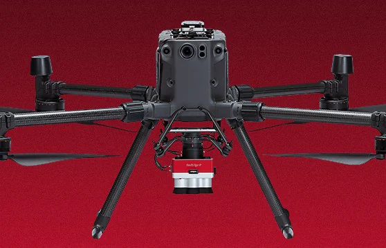
01 / LEARNING OUTCOMES
The objective is not simply to produce a colourful map. Participants should understand what the sensor measured, how calibration and acquisition affect the result, which software route is supported and where interpretation must stop.
Select spectral and thermal measurements around an application
Plan ground sampling distance, overlap, capture and storage
Apply reflectance-panel and DLS 2 procedures consistently
Process supported files and inspect output quality
Generate appropriate vegetation indices without universal thresholds
Validate anomalies with field evidence and communicate limitations
02 / CUSTOMISABLE TOPICS
Topics can be combined into a technical session or project-based programme. Content and depth depend on the participants, equipment and intended deliverables.
Understand reflected light, band selection, reflectance, vegetation indices and the difference between multispectral, thermal and hyperspectral measurements.
Review camera selection, mounts, power and triggering, DLS 2 placement, payload, geotagging and configuration-specific checks.
Plan area, altitude, ground sampling distance, overlap, capture interval, storage and environmental conditions around the intended output.
Practise reflectance-panel capture, DLS 2 operation and consistent procedures for changing illumination and repeat surveys.
Use compatible software for supported cameras, generate reflectance and index products, and export appropriate raster or GIS outputs.
Assess artefacts, compare field observations and previous surveys, and communicate analytical limitations without over-diagnosing spectral anomalies.
03 / PRACTICAL SEQUENCE
A representative practical sequence. The actual session is adapted to safety, site access, weather, equipment and participant experience.
Define the vegetation target, area, output and validation question.
Review the camera, mount, DLS 2, aircraft interface and mission settings.
Capture the reflectance reference and record incident-light and environmental conditions.
Plan or perform authorised image acquisition with appropriate overlap and quality checks.
Import supported files, apply the relevant corrections and generate agreed spectral products.
Compare anomalies with reference observations, document uncertainty and export suitable GIS layers.
Field flying is subject to a separately agreed safe and authorised operating plan. No regulatory approval or site access is implied by a training enquiry.
04 / WHO SHOULD ATTEND
Drone operators and surveying companies
Agricultural consultants and plantation teams
Environmental consultants and conservation organisations
Universities and research institutes
Government and enterprise technical users
GIS and remote-sensing specialists
05 / PROCESSING TUTORIAL
This official tutorial provides useful context, but its interface is historical. Current menus, supported cameras, correction options and exports must be verified against the installed version.
Manufacturer tutorial demonstrating multispectral image processing in PIX4Dfields. The interface is historical, so current project setup, supported cameras and export steps must be checked against the installed version.
Manufacturer imagery is used as the facade, not represented as a frame from this video. Historical software interface—verify the current version.
Open official video on YouTube06 / BRING THE RIGHT CONTEXT
Useful preparation includes the camera model, drone platform, processing software and version, application, approximate project area, participant experience and desired outputs. Do not send NTRIP passwords, subscription tokens, credentials or sensitive project information through the general form.
5 multispectral bands
RedEdge-P5 multispectral bands + panchromatic
RedEdge-P Dual10 multispectral bands + panchromatic capability
RedEdge-P Triple15 multispectral bands using three coordinated cameras
Altum-PT5 multispectral bands + panchromatic + 320 × 256 thermal
Altum-PT Pro5 multispectral bands + panchromatic/RGB + 640 × 512 thermal
07 / TRAINING FAQ
No manufacturer certification is claimed. Easepect offers customised technical guidance and project-based training around the team’s equipment, software and application.
Not necessarily. A session can focus on sensor selection and workflow design, or on practical operation using an agreed demonstration or customer configuration. Confirm equipment arrangements during planning.
A representative, non-sensitive dataset can be discussed where appropriate. Do not upload restricted imagery, credentials or sensitive site information through the general enquiry form; data handling must be agreed separately.
Processing with compatible software can be included for supported cameras and outputs. The exact agenda depends on the installed version, sensor files and required deliverables; newer configurations are not assumed to be fully supported.
No responsible workflow treats NDVI as a standalone disease diagnosis. Training explains how to interpret spectral patterns with field evidence and why professional agronomic, ecological or arboricultural assessment may be required.
Discuss the team location, equipment and intended format with Easepect. Singapore and Southeast Asia requirements can be reviewed, but travel, delivery format and availability are confirmed by quotation.
LEARNING RESOURCES
SELECT / DEMONSTRATE / INTEGRATE
Share the participant roles, current equipment, intended application and required outputs. Easepect will discuss a customised technical session without implying manufacturer certification, universal software support or standalone diagnostic capability.