GPC deliverables and handover

A point cloud is only useful when its origin, geometry and limitations travel with it.

Agree the source record, derived data, coordinate framework, attributes, QA evidence and handover manifest before capture. This prevents a visually impressive model from becoming an ambiguous project file.

Sample deliverables are shared through a contextual enquiry so that format, permissions and relevance can be checked. There is no anonymous download of client-sensitive project material.

Six output classes

Separate source evidence from interpretation.

Not every project needs every output. The contract should state what is observed, what is derived, who checked it and which party is responsible for regulated survey sign-off.

01

Geolocated 3D point cloud

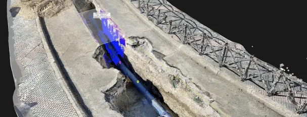
Preserve the visible trench and utility surfaces as a spatially referenced source record, with coordinate and processing context.

Typical output
LAS/LAZ or another mutually agreed supported format.
Useful for
Project engineer, surveyor, digital-delivery team
02

Textured 3D mesh / viewer

Provide an inspectable visual context where contracted, without treating the mesh as an automatic measurement or defect-detection system.

Typical output
Agreed model/viewer output and viewing instructions.
Useful for
Site and design teams
03

Vectorised utility geometry

Digitise the specifically observed or explicitly derived utility features, with clear top, centreline, invert and structure definitions.

Typical output
GIS 3D lines and relevant structure-point geometry.
Useful for
GIS and asset-information teams
04

Structured GIS data

Map geometry, asset types and attributes into the agreed project schema and validate the complete exported dataset.

Typical output
SHP component set or GDB, with coordinate metadata.
Useful for
Utility owner, Registered Surveyor, GIS manager
05

Site evidence package

Link selected photographs and capture information to the spatial record so reviewers can understand the opening context.

Typical output
Capture-date context, photographs and source references.
Useful for
QA, construction and handover teams
06

Control and QA summary

Explain the positioning framework, checks, unresolved gaps and assumptions instead of presenting the model as universally complete.

Typical output
Method, datum, checkpoints where available, exclusions and limitations.
Useful for
Technical reviewer
Manufacturer illustration of a utility trench point cloud and spatial data workflow
Manufacturer workflow illustration · Not a sample survey or Easepect project

Geometry definitions

Name the line before exporting the line.

“Utility as-built” is not a sufficient geometry definition. Top-of-pipe, outside edge, centreline and invert can describe different observations or interpretations.

  • Record what was directly visible and measured.
  • Identify where diameter or geometry was used to derive another feature.
  • Use 3D GIS lines with X/Y/Z where the applicable specification requires them.
  • Use structure points and elevation attributes according to the required schema.
  • Keep unknown attributes explicit rather than filling gaps with guesses.

Illustrative handover manifest

Make every deliverable inspectable.

This is an example scope structure, not a public sample project, survey sign-off or claimed client handover. The actual manifest and acceptance checks are agreed for each commission.

ItemPackage componentInformation to confirmPrimary recipient
01Source capture indexCapture dates, device/application, coverage notes and source-file referencesProject record
02Positioning and coordinate noteDeclared horizontal/vertical reference, correction source, control and transformationsSurvey / GIS
03Point cloud and optional meshAgreed portable formats, units, tiling, coordinate reference and processing versionSurvey / CAD / GIS
04Utility feature datasetDefined 3D lines or structure points, schema, attributes and complete SHP/GDB package where requiredGIS / submission
05Visual evidenceSelected site photographs and model views linked to the source captureAsset owner / contractor
06QA and exception summaryChecks performed, unresolved gaps, obscured surfaces, assumptions and responsible partiesAll recipients
07Handover and reuse noteIntended use, software/version considerations, retention and approved sharing routeData owner

A lone .shp is not a complete portable Shapefile delivery.

Include the required companion files, projection information and attribute schema. For relevant SLA submissions, confirm whether SHP or GDB is required and validate the complete package against the current specification.

Request a relevant sample

Review an example structure before defining your own.

Tell us whether you need a point cloud, GIS feature schema, QA summary or complete handover structure. We will confirm what can be shared lawfully and what is relevant to your workflow.

No fake download links. No client-sensitive models. No fabricated coordinates or QA values.

Request Sample Deliverables

Plan before the excavation window

Define the handover before the fieldwork starts.

Share the required formats, coordinate/height datum, geometry definitions and acceptance responsibility.

Discuss GPC