
Utility owners, contractors, survey teams and GIS professionals building an in-house exposed-utility capture workflow.
GPC / EXPOSED UTILITIES MODEL VIEW
X 31,284.192Y 28,901.417Z 102.618
ILLUSTRATIVE SPATIAL VIEWRTK · PHOTOGRAMMETRY · QA/QC
GPC Singapore · Underground Utility Mapping · 3D Trench Capture
GPC Solutions for Underground Utility Mapping in Singapore
Capture exposed pipes, ducts and underground infrastructure in 3D before backfilling. Transform site imagery into geo-located point clouds, vectorised utility geometry and GIS-ready records.
Equip your team with a practical PIX4Dcatch and Emlid RTK workflow, configured for exposed-utility capture and supported by hands-on training.
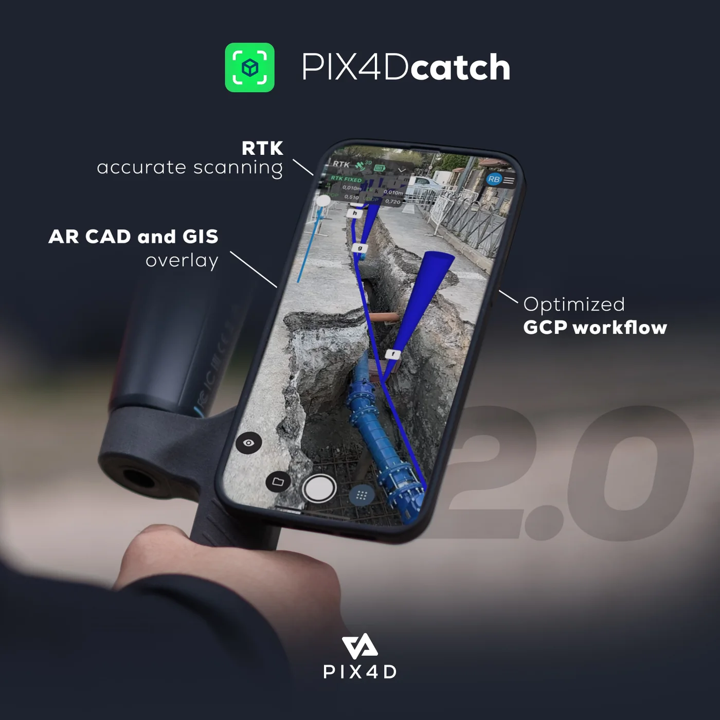 ILLUSTRATIVE GIS VECTOR
PIX4Dcatch + compatible Emlid RTK3D capture before reinstatementPoint clouds, utility vectors and GIS handover
Selected equipment and software, a configured RTK capture workflow and practical training for your team.
Start with your intended capture scope, existing devices, expected usage and training requirements.
Request a solution quoteWhy capture before backfilling?
Preserve a measurable record while the utilities are visible.
Once a trench is closed, direct visual access to pipe positions, connections and surrounding conditions disappears. Conventional photographs may document the scene without providing a reusable spatial record for engineering or GIS teams.
A Geo-Located Point Cloud (GPC) uses overlapping imagery and an agreed positioning workflow to reconstruct visible surfaces in 3D. Easepect helps your team configure the RTK positioning workflow, plan the capture, inspect the result and prepare the outputs your project needs.
Explore GPC and GIS deliverablesWhat GPC provides
Visible utility geometry, spatial context and structured records.
GPC complements project documentation and required utility surveys by preserving exposed conditions in a coordinate framework. The final scope separates source capture, derived geometry, GIS attribution and professional review.
Capture the exposed scene
Record accessible pipes, ducts, structures and surrounding context before backfilling removes visibility.
Georeference the record
Use RTK positioning to georeference the PIX4Dcatch capture directly, with independent checkpoints retained for accuracy verification where required.
Prepare usable GIS data
Vectorise agreed features, map attributes and package the point cloud, GIS data and QA context for handover.
GPC supplements required utility surveys; it does not replace them.
Visible-light photogrammetry records exposed surfaces and does not detect assets behind intact ground, concrete, water, machinery or other obstructions.
PIX4Dcatch + Emlid RTK workflow
From Trench Capture to GIS-Ready Utility Records
Capture exposed utilities with PIX4Dcatch and a compatible RTK receiver. RTK positioning georeferences the capture directly, so your team can produce a geo-located point cloud without establishing ground control points (GCPs).
01
Plan
Confirm outputs, access, exposure timing, data handling and survey responsibilities.
02
Connect
Configure the compatible receiver, corrections, mobile device and coordinate framework.
03
Capture
Record systematic overlapping views of visible utilities and surrounding context.
04
Process & check
Reconstruct the scene, inspect positioning and coverage, use independent checkpoints to verify accuracy where required, and document exceptions.
05
Vectorise & deliver
Extract agreed geometry, map attributes and prepare the GIS and QA handover.
GPC outputs / field to GIS
Explore Our GPC and GIS Deliverables
Follow one exposed-utility workflow from trench imagery to a structured handover. The sequence shows the deliverable types your team can prepare with a configured capture, processing and GIS workflow.
PIX4D MANUFACTURER WORKFLOW VISUAL01 — TRENCH CAPTURE
Record exposed utilities before backfilling
Capture overlapping imagery of visible pipes, ducts, chambers, connections and surrounding trench context while safe access is available.
Manufacturer illustration. Actual capture coverage depends on visibility, access and the agreed field method.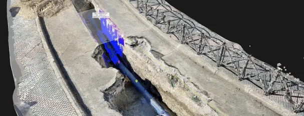 PIX4D MANUFACTURER POINT-CLOUD EXAMPLE
02 — GEO-LOCATED POINT CLOUD
Transform imagery into a referenced 3D record
Process the captured scene into a georeferenced point cloud or model, then inspect reconstruction, positioning and coverage before feature extraction.
Manufacturer example. Project coordinates, measured performance and acceptance results are established separately.ILLUSTRATIVE UTILITY VECTOR OVERLAY03 — UTILITY VECTORISATION
Extract defined utility geometry for GIS
Digitise the agreed observed or explicitly derived lines and structure points, with feature meaning, attribution and any interpretation recorded.
Explanatory green overlay on a manufacturer illustration; not a measured Easepect project output.FEATURE GEOMETRY3D Line / structure point
ATTRIBUTESAgreed project schema
COORDINATE REFERENCEProject-defined CRS and height reference
QA DOCUMENTATIONChecks, exceptions and review route
04 — GIS HANDOVER
Deliver usable files with their technical context
Prepare the specified SHP component set or GDB, coordinate information, attributes and QA documentation so the receiving team can review and use the data.
Illustrative structure only. It contains no project observations, coordinates, measured residuals or sign-off.Need to assess a format or workflow? Request Sample Deliverables Review technical deliverable details
Benefits by project role
Practical GPC Workflows for Every Project Team
Use GPC where a reusable visual and spatial record will improve documentation, coordination or GIS handover. Easepect configures the equipment, software and training around your team’s workflow.
Contractors and trench teams
Create a consistent spatial record during short exposure windows, with visible utility geometry and site context organised for later review.
Utility owners and asset teams
Receive structured 3D and GIS information that can support as-built records, asset updates and future coordination.
Survey and geospatial teams
Add an inspectable visual source to survey-controlled observations, GIS feature extraction and project QA.
Engineering and coordination teams
Review visible connections, crossings and surrounding context without relying on isolated photographs alone.
Existing 3D data holders
Assess suitable georeferenced point clouds for utility vectorisation, attribute mapping and GIS handover.
Organisations building in-house capability
Adopt a documented field-to-office workflow with equipment selection, configuration, demonstration and practical training.
Accuracy, survey and data requirements
Plan the Technical Requirements Around Your Project
Accuracy and acceptance depend on the complete observation and validation method. We identify the applicable project workflow, professional responsibilities and data-governance requirements before capture.
URA · Major Infrastructure Workflow / Enhanced Site Investigation
URA’s guidance discusses utility detection and GPC for exposed or newly constructed utilities during excavation. Applicability is established with the project authority.
Read the URA guidanceSLA · Utility Survey Standards, Version 1.3
The October 2025 standard addresses close-range photogrammetry, Registered Surveyor supervision, accuracy, GIS geometry, attributes and submission requirements for relevant utility surveys.
Read the SLA standardIndependent checkpointsUse independent checkpoints to verify accuracy against the project criteria. They serve a different purpose from ground control points and remain part of accuracy review where required.
≥ 80%Overlap between successive images under that specified photographic procedure.
±100 mmA horizontal and vertical absolute survey accuracy requirement for relevant surveys, not an automatic equipment result.
SHP or GDBSubmission formats as specified, with the required 3D GIS geometry, attributes and companion files.
Relevant new as-built and trial-trench utility surveys require direct Registered Surveyor supervision and observations before backfilling. Cloud processing requires data-owner authorisation, especially for government or critical-infrastructure sites. AR replay is not excavation clearance or a substitute for utility detection and permit procedures.
Manufacturer demonstrations
See PIX4Dcatch and RTK in Action
Watch official PIX4D examples of mobile capture, point-cloud generation and downstream utility-data use. Each example is attributed to its manufacturer.
Scanning underground utilities with PIX4Dcatch
PIX4D demonstrates utility scanning, RTK integration, point-cloud generation, vectorisation and AR visualisation. Project suitability still depends on the capture method, control and applicable survey specification.
Watch on YouTube Representative manufacturer visual. Video loads only after you select play.PIX4Dcatch utility mapping workflow with RTK
A manufacturer introduction to capture, processing and subsequent utility-data use, including the field configuration and coordination needed for a practical workflow.
Watch on YouTube Representative manufacturer visual. Video loads only after you select play.PIX4Dcatch + Emlid RTK for your team
Build a repeatable trench-capture workflow.
Equip your team to capture exposed utilities before backfill. Easepect supplies the PIX4Dcatch + Emlid RTK solution, configures the workflow and trains your team to use it on site.
Singapore industry engagement
Geospatial Workflows Demonstrated with Industry Stakeholders
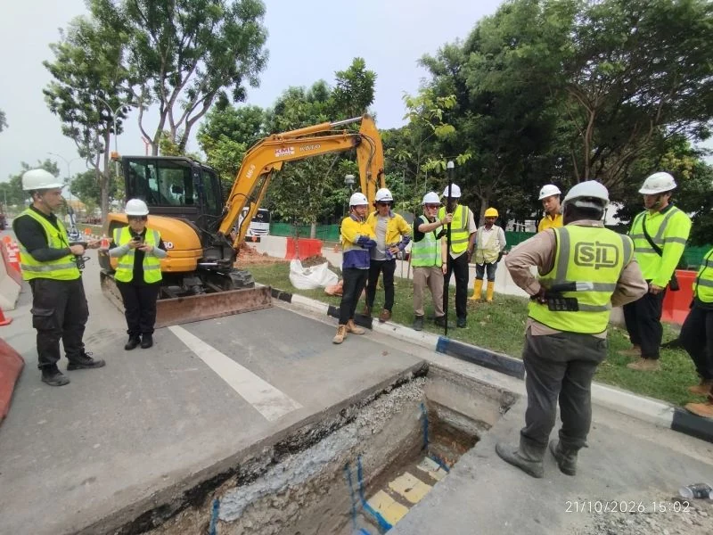
Easepect participated in an on-site PIX4Dcatch and Emlid RTK trench-documentation demonstration in Singapore, where Singapore Land Authority demonstrated the workflow to JTC; Easepect was represented by Kenneth Pan.
This engagement informs our practical approach to capture planning, technology demonstrations and professional knowledge sharing. Regulated survey responsibilities and project acceptance remain with the appropriately appointed parties.
GPC and utility mapping FAQs
Frequently Asked Questions About GPC Utility Mapping
Understand capture timing, RTK georeferencing, independent checkpoints, visibility, accuracy assessment and deliverables before choosing your equipment and training.
Read all technical GPC FAQsIt is a geolocated 3D point-cloud record of a site, used here to document utilities that are visible during excavation. It adds spatial and visual context; its suitability for a particular handover depends on control, data quality, attributes and specification.
No. GPC describes a type of captured 3D record. SLA’s utility-survey standard specifies survey responsibilities, control, observation accuracy, feature formats and attributes for relevant utility surveys. GPC can support a workflow, but cannot be treated as a substitute for every requirement.
For the PIX4Dcatch + RTK workflow shown on this page, RTK positioning georeferences the capture directly, so your team can produce a geo-located point cloud without establishing ground control points (GCPs). Independent checkpoints can still be used to verify accuracy; they serve a different purpose from GCPs. This statement is specific to PIX4Dcatch with a compatible RTK receiver.
Accuracy is not fixed by the software name or GNSS receiver alone. It depends on control, scene texture, camera geometry, satellite reception, capture quality, processing and independent checks. SLA Version 1.3 specifies ±100 mm horizontal and vertical absolute survey accuracy for relevant new as-built and trial-trench utility surveys; actual performance must be demonstrated against the project’s criteria. Manufacturer centimetre-level claims are not a per-project acceptance certificate.
No. It reconstructs visible surfaces from imagery. For concealed utilities, use appropriate records and detection/survey methods such as GPR or EML as specified. GPC is most useful while the trench or utility is exposed.
Yes, if the intention is to document exposed utility surfaces. Plan the survey observations, capture and site checks before works conceal the assets. For new as-built and trial-trench surveys, SLA Version 1.3 requires direct observations before backfilling.
Yes, where contracted and supported by the source data and processing workflow. A real Shapefile delivery includes companion files such as SHP, SHX, DBF and PRJ, and the attribute and geometry schema must be checked. SLA’s utility-survey standard specifies 3D GIS lines for appropriate utility line features and allows SHP or GDB submissions.
Share your intended PIX4Dcatch + RTK capture scope, existing compatible devices, expected usage, software requirements and team-training needs. Independent checkpoint requirements can be discussed separately from equipment selection. Do not submit sensitive site information or credentials through the general enquiry form.