
BIM coordinators, facility teams, engineers and owners working from observed existing conditions.
 Technology partner / Spatial intelligence
AI-Powered Scan-to-BIM · As-Built Digital Modelling
From Point Cloud to BIM.
Faster, Smarter, More Connected.
Transform captured reality into structured 3D building information using AI-assisted Scan-to-BIM technology.
Easepect combines reality-capture workflows with CyberGEO’s modelling and spatial intelligence solutions to support building documentation, infrastructure modelling, asset management and digital twin applications.
01 / CAPTURED REALITY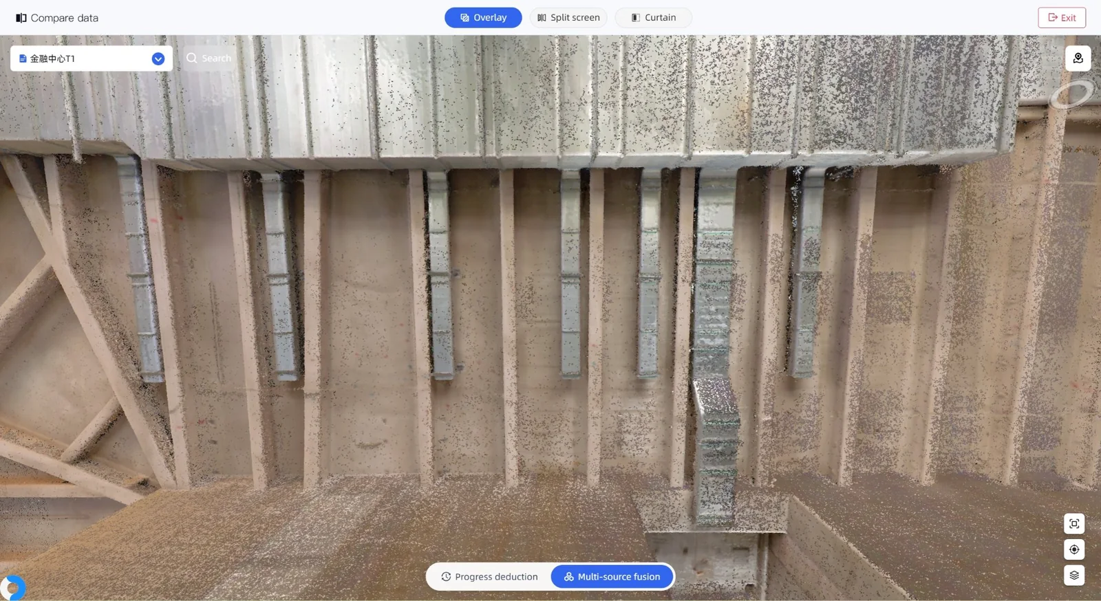
02 / STRUCTURED MODEL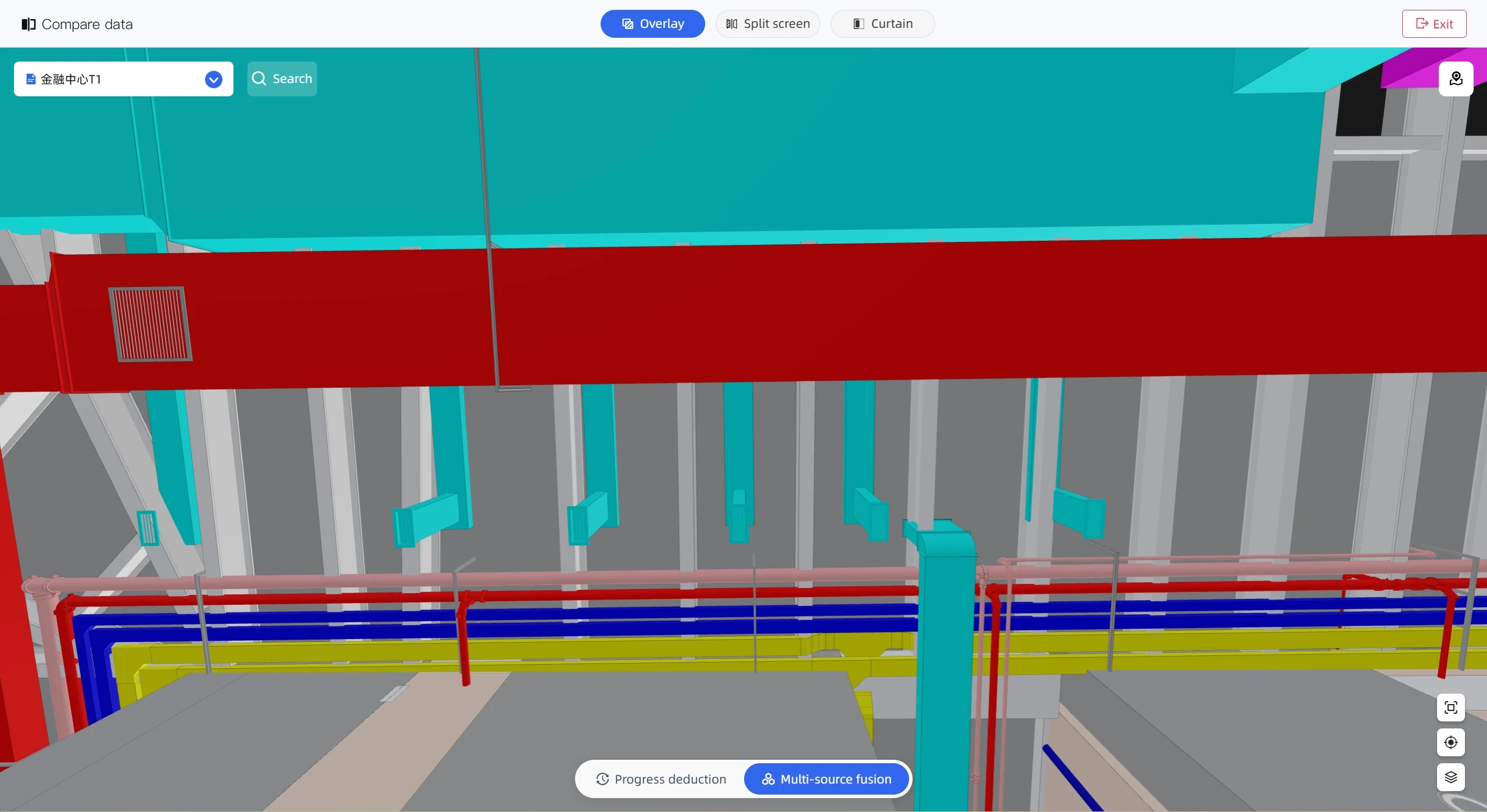
AI-assisted, human-reviewedPoint cloud · BIM · GIS · digital twinsFormats and acceptance agreed per project
Registered source data, an agreed model or comparison outputs, and documented modelling assumptions and QA.
Identify the asset zones, source point clouds, receiving software, required detail and acceptance responsibility.
Start a technical assessmentA connected modelling discipline
Structured information.
With the evidence still attached.
CyberGEO develops spatial intelligence technologies that transform reality-capture data into structured digital assets. Its solutions bring together point clouds, BIM, GIS and digital twin technologies to help organisations digitise, visualise and manage complex built environments.
Through this technology partnership, Easepect connects field-capture expertise with AI-assisted modelling and digital asset workflows. The goal is not an unattended conversion: it is a useful, reviewed model with clear source, format, completeness and acceptance boundaries.
Read the detailed service scopeObserved geometry
What the authorised capture actually recorded, including gaps and occlusion.
Modelled information
Which elements and properties were intentionally created under agreed rules.
Verified handover
Which checks, formats and professional responsibilities define acceptance.
Core solution capabilities
From reconstructed surfaces
to structured digital assets.
Six connected capabilities address modelling, comparison and downstream use. Each remains subject to suitable source data, supported formats and explicit review.
AI-Assisted Scan-to-BIM
Convert suitable point-cloud datasets into structured BIM representations using CyberGEO’s AI-assisted modelling workflow.
Reduce repetitive modelling activities while retaining engineering review, source-data inspection and quality control.Existing Building Modelling
Create digital representations of existing structures for renovation, refurbishment, building documentation and structural-layout understanding.
Model scope can also support asset and facility-management preparation where the required information structure is defined.MEP & Industrial Facility Modelling
Support modelling of visible mechanical, electrical and plumbing installations, plant equipment, piping networks and industrial assets.
Potential applications include plant rooms, gas facilities, substations and utility infrastructure, subject to coverage and safe access.Point Cloud vs BIM Comparison
Compare captured reality with a digital model to review geometric differences, missing elements or discrepancies.
Actual comparison functions, detection rules and report formats must be verified for the proposed solution; a difference is not automatically a defect.Infrastructure Digital Twins
Bring suitable spatial and engineering information together to support digital representations of infrastructure assets.
Potential environments include industrial plants, tunnels, stations and utility facilities, with scope and governance agreed in advance.Spatial Data Integration
Explore BIM, point clouds, GIS and other asset information within a connected environment.
Supported formats, coordinates, deployment and integration behaviour are confirmed before a connected workflow is specified.How the workflow operates
Reality Capture → Point Cloud → AI-Assisted Modelling → BIM Review → Digital Asset Delivery
The model is one stage in a controlled information workflow—not a substitute for capture quality, professional review or acceptance criteria.
STEP 1Reality capture
Capture
Acquire suitable site data using compatible reality-capture equipment and workflows, such as mobile mapping systems, laser scanners or photogrammetry.
Coverage · access · coordinate frameworkSTEP 2Point cloud
Prepare
Register, clean and review the point cloud, establishing appropriate coordinates and the information quality required for modelling.
Registration · cleaning · source QASTEP 3AI-assisted modelling
Model
Apply CyberGEO’s AI-assisted Scan-to-BIM workflow to create a structured representation of the captured environment.
Element scope · classification · modelling rulesSTEP 4BIM review
Validate
Compare the BIM representation against source data and review geometry, completeness, classification and the required Level of Information Need.
Human review · exceptions · acceptance criteriaSTEP 5Digital asset delivery
Deliver
Provide agreed BIM models, related 3D information and digital asset outputs in supported formats.
Verified formats · documentation · handoverExport compatibility is a verification task. IFC, native authoring formats and other deliverables are confirmed only after the required format, receiving software, geometry and information structure have been checked.
Point cloud vs BIM / matched example
Inspect the source.
Interrogate the model.
Move the divider to compare CyberGEO’s official captured-reality and structured-model views. This demonstrates the comparison concept; it is not an Easepect project result, an accuracy certificate or automated defect report.
CAPTURED REALITYSTRUCTURED BIM MODEL01
Review geometry against the retained source data
02
Separate observed differences from modelling interpretation
03
Verify missing elements, rules and reporting in the proposed workflow
Industry applications
Define the asset scope
before modelling the site.
These are potential application scopes, not claimed Easepect customer case studies. Each pairs the point-cloud review with the intended BIM modelling scope; only the official matched visual above is presented as reality/model evidence.
Electrical substations
Document accessible structures and above-ground equipment to support agreed modelling, coordination and asset-information scopes.
POINT-CLOUD REVIEW
Visible building geometry, equipment envelopes, cable containment and accessible spatial clearances.
BIM MODELLING SCOPE
Agreed structural and equipment elements, spatial zones and asset classifications required for coordination.
Warehouses
Create an existing-condition representation for layout planning, refurbishment, fit-out and operational documentation.
POINT-CLOUD REVIEW
Floors, walls, columns, roof structure, doors, racks and visible building services within the captured areas.
BIM MODELLING SCOPE
Agreed architectural, structural and services elements at the specified detail and information level.
MEP systems
Structure visible building services into a model that supports coordination and agreed asset-documentation requirements.
POINT-CLOUD REVIEW
Accessible pipes, ducts, conduits, trays, plant and connections, with sufficient views to interpret geometry.
BIM MODELLING SCOPE
Specified service families, routes, sizes where supportable, equipment and required properties.
Gas facilities
Assess authorised reality capture and modelling of visible above-ground assets without implying process or safety certification.
POINT-CLOUD REVIEW
Permitted work areas, structures, equipment, piping and access context under the facility’s operating rules.
BIM MODELLING SCOPE
Priority assets and spatial information defined by the asset owner, engineer and intended downstream use.
Tunnels
Build structured representations from suitable capture of accessible tunnel geometry and installed visible systems.
POINT-CLOUD REVIEW
Lining, walkways, portals, visible services and agreed infrastructure features with documented coverage gaps.
BIM MODELLING SCOPE
Specified linear geometry, structural elements, service routes and asset groupings for the intended workflow.
Industrial plants and stations
Prioritise complex facilities by zone, system or decision rather than assuming every visible item must become a BIM object.
POINT-CLOUD REVIEW
Structures, platforms, equipment, piping and visible services within accessible and authorised capture zones.
BIM MODELLING SCOPE
Agreed priority systems, spatial envelopes, asset structure and related information for coordination or operations.
Connected Easepect solutions
A workflow across capture,
spatial data and operations.
These are possible workflow connections, not claims of direct software interoperability. Formats, versions, coordinates and integration steps must be tested for the proposed stack.
01 / Capture
NavVis MLX & reality capture
Assess mobile mapping and other suitable capture routes for existing buildings and industrial environments. Equipment availability and project fit are confirmed per scope.
02 / Spatial dataPIX4D photogrammetry
Process suitable imagery into point clouds and related 3D spatial data, with acquisition and reconstruction quality reviewed before modelling.
03 / Prepare & connectGlobal Mapper
Review point clouds, GIS data, coordinates and agreed preparation tasks within the relevant subscription and supported formats.
04 / Visual asset contextFRAMENCE digital twins
Consider navigable photographic site records and visual asset documentation alongside, or instead of, a geometric BIM deliverable.
05 / Downstream operationsspeedikon FM
Explore potential facility-information management applications after asset structure, data ownership and integration requirements are defined.
REALITY CAPTUREPOINT CLOUDAI-ASSISTED MODELREVIEWED DIGITAL ASSET
Official CyberGEO demonstration / 00:10
AI-Powered Scan-to-BIM — From Captured Reality to Structured 3D Models
Watch CyberGEO’s short demonstration of AI-assisted modelling and a point-cloud/model transition. The clip presents the workflow; suitability and outputs for substations, warehouses, MEP systems, gas facilities, tunnels and industrial plants are assessed separately.
The poster is an actual frame extracted from the local review copy. No temporary external media URL is used.
Explore CyberGEO’s official product workflowCommercial pathways
Commission the outcome.
Or evaluate the technology.
Start with the asset, available data, required model and downstream use. Easepect can then define an appropriate service, demonstration or consultation scope.
Scan-to-BIM Project Service
For organisations requiring existing-condition data to be converted into an agreed, reviewed BIM deliverable.
Discuss your projectAI Scan-to-BIM Technology Demonstration
For contractors, consultants and asset owners evaluating AI-assisted modelling capabilities and workflow fit.
Request a demonstrationDigital Twin & Asset Integration Consultation
For organisations planning to connect reality capture, BIM, GIS and facility-management information.
Plan the integration reviewScan-to-BIM FAQ
Before the point cloud becomes a deliverable.
Understand the modelling, compatibility, acceptance and data-governance decisions that belong in the technical assessment.
A visually convincing model is not, by itself, evidence of accuracy, completeness or engineering acceptance.
No. AI-assisted modelling can reduce repetitive work, but source-data quality, element interpretation, completeness and engineering review remain necessary. Easepect does not promise error-free or unattended modelling.
Suitability depends on coverage, registration, noise, scale, occlusion, feature visibility and the intended model. An initial technical assessment determines whether the available data supports the requested scope or further capture is advisable.
Provide the actual format and producing software in the enquiry—for example LAS/LAZ, E57 or another proprietary exchange format. CyberGEO workflow support and any conversion requirements must be checked rather than assumed.
The required receiving software, version and deliverable format are confirmed during scoping. IFC or native authoring outputs are included only after actual export compatibility and the required information structure have been verified.
The project should define source-data checks, modelling tolerances, acceptance criteria and responsible reviewers. Visual alignment alone is not an accuracy certificate. Critical dimensions and professional acceptance require the agreed engineering or survey verification process.
Only if that is the agreed and achievable scope. Element categories, Level of Information Need, exclusions, occluded areas and unresolved features should be documented. Model completeness is reviewed against that scope, not assumed from a screenshot.
A local or cloud processing preference can be assessed. Deployment support, hardware, licensing and data governance must be confirmed. Restricted project data should not be uploaded to a cloud service before the data owner approves the arrangement.
The connections shown are possible workflow stages, not a claim of certified direct interoperability. File formats, coordinate behaviour, versions and any exchange or integration steps must be tested for the proposed stack.
Start with a technical assessment
Turn Your Point Cloud into an Intelligent Digital Asset
Share the high-level project scope, available point-cloud format, intended BIM output, information requirements and acceptance criteria. Easepect will help assess the capture, modelling and delivery route with CyberGEO.
Do not submit sensitive site information, controlled models or plans, credentials or restricted project data through this general enquiry form. Secure transfer and processing arrangements can be discussed separately where approved.